°F
VIEW REPORT 
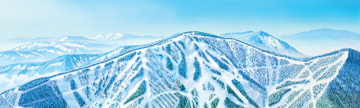
 Easiest
 More Difficult
 Most Difficult
 Experts Only. Use extreme caution
 Glade Runs
Skiers and riders should be advised A green circle, blue square or Black Diamond trail at one ski area is not necessarily the same as a similarly rated trail at another ski area. Skiers and riders should work their way up, beginning with the easiest trails, no matter what their ability level may be, until they are familiar with the trails at that ski area.
BOUNDARY POLICY Skiers and snowboarders wishing to go outside of marked area boundaries do so at their own risk. Areas outside of marked boundaries are not patrolled. Unmarked hazards of all types exist. Search and rescue operations may be authorized and conducted by Stevens County Sheriff's Department. You or your heirs will be financially responsible for this service.
Any person skiing or riding outside the confines of trails or runs open for skiing and snowboarding within the ski area boundary shall be responsible for any injuries or losses resulting from his or her actions.
DRONE POLICY Drones or model aircraft use by guests, commercial operators or the media is prohibited without prior written approval of 49° North Mountain Resort.
UPHILL POLICY . Please read the entire uphill policy here.
EasiestMore DifficultMost DifficultExperts Only. Use extreme cautionGlade Runs


